Let's talk GPS systems...

NMTerras

Suspension Lift
Location
New Mexico
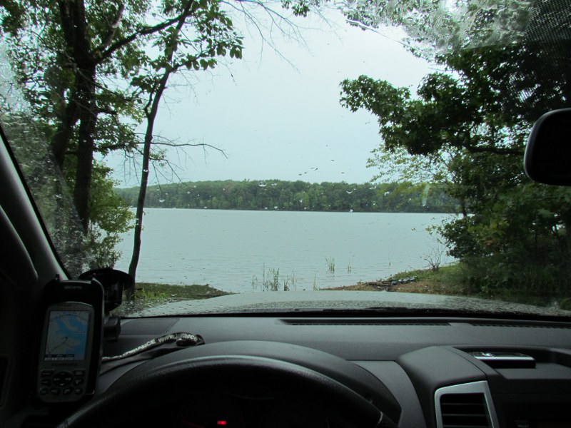
While looking at a member's hand-held Garmin for sale, it occurred to me I really don't know enough to make an informed decision about which GPS system is right for me. What I'm looking for is something that helps me figure out where I am and where I'm going in the mountains, in remote areas. Are the bigger car mounted units equipped for that sort of thing, or are they only good for driving directions in cities and such? I'd prefer one of the bigger screened car-mounted units, but if I have to go hand-held to get topographical info, etc., so be it...

Thoughts? Experiences? Reviews?
 

granitex

Skid Plates
Founding Member
Location
Columbus OH
For the topo type of stuff I really like to use my netbook. I can load a couple of different topo maps Garmin and Nat Geo) and find just about anything that i could ever want. With a custom mount it is convient and out of the way, the GPS dongle is on the dash with the USB cord hidden and coming out through the bottom under the radio.

For most on road travel I just use a cheap TomTom that I picked up used. It is attached to the wind shield and I can take it from truck to car when needed.

With the way that phones have gone in the last few years I also use it on occasion, but being kind of cheap and not wanting to pay for all of the data I usually just use the TomTom.
laptop.jpg

That is an older pic with a laptop, it has been cut down to fit a netbook now.
july018.jpg

How the mount attaches to the seat.

You can sit in the passenger seat with it all there, I would not want to do it cross country but across town, or out on a trail it is not bad.
 

granitex

Skid Plates
Founding Member
Location
Columbus OH
If all that I want to do is map a trail I will use either my old garmin hand held, or my phone, and usually the old Garmin.
 

NMTerras

Suspension Lift
Location
New Mexico
For the topo type of stuff I really like to use my netbook. I can load a couple of different topo maps Garmin and Nat Geo) and find just about anything that i could ever want. With a custom mount it is convient and out of the way, the GPS dongle is on the dash with the USB cord hidden and coming out through the bottom under the radio.

For most on road travel I just use a cheap TomTom that I picked up used. It is attached to the wind shield and I can take it from truck to car when needed.

With the way that phones have gone in the last few years I also use it on occasion, but being kind of cheap and not wanting to pay for all of the data I usually just use the TomTom.
laptop.jpg

That is an older pic with a laptop, it has been cut down to fit a netbook now.
july018.jpg

How the mount attaches to the seat.

You can sit in the passenger seat with it all there, I would not want to do it cross country but across town, or out on a trail it is not bad.

Hmmm not seeing any pics...

I use my smartphone for around town stuff. I suppose i could load topos on the ipad...

But what I'm curious about is what works best, GPS-wise, out in the boonies
 

J Everett

Suspension Lift
Founding Member
Location
Houma, LA
Some of the higher end Garmin nuvis can run topographical maps but they don't come loaded in the device. You have to buy the topo maps separately, and they are not cheap. Alternatively, you can get topo map apps for iPhone, iPad, and android phones/tablets. I use MotionX on my Nexus tablet, which works pretty good. Dual makes an external WAAS enabled antenna that is compatible with iPad and some Android tablets for more accurate pinpointing of your location.

Or you can get a WAAS enabled handheld that just gives you coordinates and waypoints and plot your course out by hand on a paper map. I also do this, as it's a good back up and a really good skill to have and hone. Most handhelds these days also have maps anyway. I like the Delorme Earthmate, but the Garmins are excellent as well.
 

NMTerras

Suspension Lift
Location
New Mexico
OK, definitely going to use my Ipad for this. Now i have to decide between the Dual and Bad Elf for the GPS antenna...decisions, decisions...I like the fact Bad Elf doesn't require it's own power source
 

NismoFire

Titan Swapped / SAS'd
Founding Member
Location
Smyrna, TN
You won't be disappointed with that RAM mount. BIL put one in his Tahoe for his Asus tablet and that thing is amazing.
 

TheFauxFox

Titan Swapped / SAS'd
Founding Member
Location
Huntsville, AL
Some of the higher end Garmin nuvis can run topographical maps but they don't come loaded in the device. You have to buy the topo maps separately, and they are not cheap. Alternatively, you can get topo map apps for iPhone, iPad, and android phones/tablets. I use MotionX on my Nexus tablet, which works pretty good. Dual makes an external WAAS enabled antenna that is compatible with iPad and some Android tablets for more accurate pinpointing of your location.

Or you can get a WAAS enabled handheld that just gives you coordinates and waypoints and plot your course out by hand on a paper map. I also do this, as it's a good back up and a really good skill to have and hone. Most handhelds these days also have maps anyway. I like the Delorme Earthmate, but the Garmins are excellent as well.

2x on MotionX. Bought it when it was on sale.
 

Silver dude

Sliders
Founding Member
Don't forget about the Backcountry navagator app. Works well. I'm planning to buy a Nexus 7 and mount it near the a/c controls. When overlanding the large but not to large screen would be handy. Ipads are the way to go for many. I just feel the screen may be to large for our cockpits while driving. But, when you get to camp it would be fun to show movies on. If I had the money I'd go Ipad. But, android tablets are cheap. Some include built in GPS.
 

mudchet

Got Mud?<br><img src="http://i164.photobucket.com/
Founding Member
Location
Brentwood, TN
Ah yes apps...the next phase...motionX? Backcountry navigator? Gaia? Topomaps? Discuss....

I an running an iPad, ram mount and the motionx, drives apps. Havent used the motionx GPS HD app much yet. Will do that at NXM2. The driveX app is as good as any built in nav system and I like that you can download map data ahead of time so I dont rack up celluar charges. Like others, I agree that the ram mount is the best mount for the ipad. I looked at a few and did some research and the ram seemed tobe the best performer.
 

yellowbug

First Fill-Up (of many)
Location
Ga
I have an app on my old droid that I only use as a gps. Sometimes I can not get maps out in the woods because of no wifi but the compass still works and it continues to log my gps signal.
 

Xtacular

Bought an X
Founding Member
Location
Washington
Topography and technology are not in the slightest mutually exclusive :)

For personal use I use a Garmin GPSMAP unit, very good receiver. At work I use a Trimble Yuma loaded via ArcMap :D Also an iPad with the Fulcrum app.
 

ymbhonk

First Fill-Up (of many)
Location
Puyallup, WA
I find that for road driving a Tom Tom is the best you can get. Mostly due to the updates for maps not costing millions. Off road I always have a topo and a mil spec compass and also carry a garman foretrex 401.

It al depends on what you are used to. I can't tell you anything with lat long. But give me a 10 digit grid and I'll point right to it.
 

J Everett

Suspension Lift
Founding Member
Location
Houma, LA
I was wondering when/if someone was gonna mention Trimble. We used Trimble GPS equipment when I was surveying. It is the bomb; if you can afford it, definitely go for the Trimble gear.
 

Airmapper

First Fill-Up (of many)
I really want an older Lowrance Baja unit. Reason being is it's a rugged unit for off road racing, and I happen to already have the mapping software, if I can get a computer rigged to run it. They are darn expensive though, and I can't seem to find any older used units that are even down where I will pay for them. Finding parts for the connections, like the antenna, will be difficult.

baja-lowrance-hds5.jpg


Pretty chunky box, so don't know how well it would work in the X. As with a lot of my off road gear I'm looking to make stuff interchangeable with my Bronco, as in undock it from one, set it in the other, and go.

This is my handheld Lowrance Expedition C, which I use in the vehicle primarily if I know generally where I am. (It's not a highway unit) Has topo and most old roads on the map.

IMG_2309_800x600.JPG
 

TKDx00

Lockers Installed
Founding Member
I've got a Garmin. Did an update just before nXm2. D@MN thing had me all over gobble's creation on the ride down.
I ride the train with a woman who's company supplies the maps for Garmin... believe you me I will be having a talk with her!!!!
 

Macland

Titan Swapped / SAS'd
Founding Member
I've got a Garmin. Did an update just before nXm2. D@MN thing had me all over gobble's creation on the ride down.
I ride the train with a woman who's company supplies the maps for Garmin... believe you me I will be having a talk with her!!!!

Please do! Their maps are dated whenever they come out it seems. Mine took me off an interstate and through a dang airport parking garage in Albuquerque one time.
 

J Everett

Suspension Lift
Founding Member
Location
Houma, LA
I'm guessing she works for Navteq. Their maps are still not showing a new road that's been open here for two years. My Garmin thinks I'm driving over open water when I'm on that road.
 
Last edited:

TKDx00

Lockers Installed
Founding Member
She told me awhile back that they have vehicles that they have to actually drive over roads to map them. So I'm guessing that they just haven't been back over them and don't know they exist. My questions for her would be how the decisions are made on how it chooses a road. That software needs tweeking. It took me off the interstate as well and ran me thru towns just to get back to the same interstate I was originally on...WTF?!?!?!
 

Macland

Titan Swapped / SAS'd
Founding Member
She told me awhile back that they have vehicles that they have to actually drive over roads to map them. So I'm guessing that they just haven't been back over them and don't know they exist. My questions for her would be how the decisions are made on how it chooses a road. That software needs tweeking. It took me off the interstate as well and ran me thru towns just to get back to the same interstate I was originally on...WTF?!?!?!

That's a poor business plan. You've gotta do better than only changing the maps when your special vehicle drives over the roads.
 

J Everett

Suspension Lift
Founding Member
Location
Houma, LA
Hmmm, I wonder if I can get a side job driving the special Navteq mapping vehicle in my area...


EDIT: Navteq's website has a function that allows you to report mistakes and additions.
 

J Everett

Suspension Lift
Founding Member
Location
Houma, LA
No openings available, at least not on the website. All those drivers with the cake job want to keep it, it seems. Can't blame em. Maybe Google needs someone to drive the Street View car in my area....
 
Top